
Kancamagus Highway - Things to Do in New Hampshire
Working Joe Travel uses affiliate links. If you buy through them, we earn a commission. Thank you for supporting our site.

Searching for things to do in New Hampshire? Experience some of the best scenery the state has to offer on the Kancamagus Highway. The 34.5 mile American Scenic Byway cuts a path through the heart of White Mountain National Forest. See towering granite cliffs, dramatic peaks, and pristine waterfalls on this epic mountain drive.

Along the route, explore the Swift River, Albany Covered Bridge, Sabbaday Falls, and the Rocky Gorge. Cool off with dip in Lower Falls or go for a hike in Lincoln Woods. Beautiful throughout the year, the highway is especially breathtaking during the fall foliage.
In our article, gain all the information you need to plan a great day on the Kancamagus Highway.


NEW HAMPSHIRE TOURS

WHAT’S IN A NAME: THE KANCAMAGUS SCENIC BYWAY
Mt. Kancamagus and the Scenic Byway are named after Kancamagus, the final chief of the Penacook Confederacy (a union of Native American tribes). Chief Kancamagus is known for trying to maintain peace with the English settlers. When this was not possible, in 1691, he led his people into northern New Hampshire and Quebec, Canada to escape expansionism.

The Kancamagus Highway (also known as the Kancamagus Scenic Byway) is often mispronounced. The correct pronunciation is Kanc (rhythms with tank) – ah – mah – gus. But, almost no one says it this way, opting instead for “Kangamangus” or “Kancamangus.” If you don’t want to sound silly, just call it “The Kanc” like the locals do.

WHERE IS THE NEW HAMPSHIRE KANCAMAGUS HIGHWAY
The Kancamagus Highway (NH Route 112) is located in northern New Hampshire. The route can be accessed in Lincoln on the western end, or Conway on the eastern end. In addition to its stunning natural environment, the Scenic Byway is recognized for its lack of commercial development – there are no gas stations, restaurants, or other businesses along the route.
TRIP ESSENTIALS
For almost every New Hampshire travel destination, I find myself reaching for my Eddie Bauer Rainfoil Jacket, Frogg Toggs Hat, Merrell Hiking Boots, and Crocs Strappy Sandals (wear to dinner or the pool).
Other items I rely on include my Huk Sunglasses and Contigo Autoseal Water Bottle (no spills in the backpack).
But by far, my number one can’t-do-without essential is my Sony RX100 Compact Camera. It fits perfectly into a pocket. Or, mounted on a Mini-Tripod it slips into my Travelon Sling Bag.
As an Amazon Associate we earn from qualifying purchases.

Getting There
The closest major airports to The Kanc are in Portland ME (55 miles or 89 km) or Boston MA (130 miles or 209km). There is no public transportation in or around the White Mountains of New Hampshire. In the fall foliage season, commercial bus tours from nearby cities do frequent the area.

The best way to get to (and get around) the Kancamagus Highway is by private vehicle. The route can be driven in either direction. You will see many cars, motorcycles, and campers on the road. We do not recommend bike riding as there are narrow shoulders, many blind curves, steep mountain passes, and no designated bike lane.
Click here for information on Car Rentals in New Hampshire.

BEST TIME TO DRIVE THE KANC
Drive the Kancamagus Highway in the summer and fall for spectacular mountain views and warm weather activities: picnicking, swimming, hiking, and sightseeing. Drive The Kanc in the winter for brilliant snowscapes and access to hundreds of miles of cross-country ski and snowshoe trails.

For Fewest Crowds
Take the drive on a weekday
Start in the early morning; traffic is heaviest between 11-3pm
Avoid weekends, holidays, and area festivals
Make the drive in the spring. March and April are mud and bug season in New Hampshire.

For the Safest Drive
As local New Hampshire-ites, we travel this route a few times a year. It’s beautiful in all seasons and weather, but be aware road conditions can change fast. Don’t take the route in heavy rain or snow. And, know that road conditions can change quickly at dusk when ice can form with dropping temperatures.

THINGS TO DO IN NEW HAMPSHIRE

KANCMAGUS HIGHWAY FOLIAGE
The Kanc is one of the most popular destinations for leaf-peeping in the United States. In the autumn, the forest’s many sugar and red maple trees turn to vivid shades of red and orange, while its white birch manifest in dazzling yellows.

The start of the fall foliage typically begins by mid-September. In higher elevations peak color is reached around the last week of September. Lower elevations usually peak during the first two weeks of October.

These peak foliage weeks draw the biggest crowds of the year, and traffic can slow significantly. Expect bottlenecks and full parking lots around scenic outlooks and popular hiking trails. Despite the crowds, the vibrant colors still outweigh the inconvenience of the masses. If you get a chance to experience The Kanc during peak foliage, take it!

KANCAMAGUS HIGHWAY MAP

KANCAMAGUS DRIVE DETAILS
Construction: Dirt paths originating from the towns of Lincoln and Conway were connected in 1959, and paved in 1964. The road was first plowed for winter travel in 1966.
Stats: The highway is 34.5 miles (55.5km) long. Highest elevation is 2,855’ (Kancamagus Pass).

Drive Duration: Driving NH Route 112 at the posted speed limit would take about 45-60 minutes. With stops for scenic overlooks and short hikes – plan for a 3-4 hour outing.
Fees: It is free to drive the Kancamagus Highway. However, to park anywhere in the White Mountain National Forest you will need to purchase a daily recreation Pass (available online, at ranger stations, and at self-serve pay stations along the route).

Services: There are no gas stations, restaurants, stores, or commercial businesses along the route. Fill up before you hit The Kanc.
Restrooms: There are restrooms located at major stops along the route (Lincoln Woods Trailhead, Hancock Overlook, Sabbaday Falls, Rocky Gorge, Lower Falls, and more).

Accessibility: Lots close to the main scenic overlooks (Pemigewasset, Sugar Hill, Hancock, and Wagner) are paved and relatively flat, often with a paved path leading to a wheelchair accessible gazebo. Areas further away from parking lots and overlooks are likely not accessible.

PACKING ESSENTIALS
We rely on a combination of bags: Our Level-8 28” and Level-8 20” spinners are fun and stylish. Our Delsey Helium 28” hardshell is a workhorse. Our Tomtoc Backpack is great for short trips.
Randy doesn’t use them, but I swear by segregating items into Compression Packing Cubes and Wet Bags.
For security, we place an Apple Air Tag in each bag, and keep a supply of RFID Blocking Sleeves on hand.
As an Amazon Associate we earn from qualifying purchases.

WHERE TO STAY IN THE WHITE MOUNTAINS
There are six campgrounds located along The Kanc that are operated by the White Mountain National Forest. All of the areas have drinking water, fire pits, restrooms, and picnic tables. Most of the campgrounds operate on a first-come, first-serve basis. Here are the campgrounds:
Hancock Campground
Big Rock Campground
Passaconaway Campground
Jigger Johnson Campground (has coin operated showers)
Blackberry Crossing Campground
Covered Bridge Campground (takes online reservations)

Iron Rich Water - Rocky Gorge
If camping isn’t for you, we recommend booking accommodations in Lincoln or Conway. Both towns offer many eateries, shops, and outdoor activities. Here are a few well-reviewed hotels:
North Conway Grand Hotel - located on Settlers Green Outlets, North Conway
Merrill Farm Inn - historic inn in the heart of North Conway
Village of Loon Mountain - located at the base of the Loon Mountain, Condo-style lodgings
River Walk Resort at Loon Mountain in Lincoln. On-site winery, Italian restaurant, spa, and pool

THINGS TO SEE AND DO ON THE KANC
In this section we have listed our favorite overlooks and things to do on the Kancamagus Highway. Distances listed are in miles, traveling east from Exit 32 off of I-93 in Lincoln, NH.

Lincoln Woods (Mile 4.5)
The Lincoln Woods recreational area offers access to a variety of trails and old logging roads. One well-known hike is the Lincoln Woods Trail (2.6 miles or 4.2km). The family-friendly trail following an abandoned railroad bed along the Pemigewasset River.

Hancock Overlook (Mile 12.7)
This popular scenic overlook pops up just after a switchback turn called “The Pin.” The viewpoint offers sweeping vistas of the Osceola range. Great spot for watching the sun set.

Kancamagus Pass & Wagner Overlook (Mile 14.2)
The highway’s highest point, Kancamagus Pass, is marked by a sign across from the Wagner (aka Wangner) Overlook. Find panoramic views of the Swift River Watershed here. Good spot for watching the sun rise.

Sabbaday Falls, (Mile 20)
A short (uphill) 15 minute hike will take you from the parking area to a picturesque cascading waterfall. Between falls there are a series of crystal clear mountain pools.

Rocky Gorge Scenic Area, (Mile 25)
A rush of water squeezes through a narrow gorge to form a waterfall at Rocky Gorge. The tumbling torrent of water is just a short walk from the parking lot.

Lower Falls, (Mile 27)
Lower Falls is a popular swimming and picnicking spot. At the falls, the Swift River rushes over granite stones that have worn smooth over time. Discover small sandy beaches, natural water slides, and great boulders to sunbath on.

Albany Covered Bridge, (Mile 27.8)
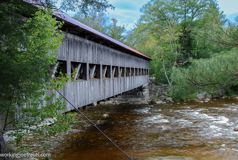
Constructed in 1858, the working bridge spans the Swift River (no vehicles exceeding 7’ 9”). Find a parking area and interpretive panels near the bridge.

Goodbye from the land of the Pemigewasset, Laura and Randy
For more information on New Hampshire travel, read our travel blog posts on:
IF YOU LIKE THIS POST, PIN IT!


Comments